[This article originally appeared in "The Dorrill-Dorrell-Darrell File" in two parts: Part 1 was in 1990-Issue No. 6, and Part 2 in 1993-Issue No. 14.] Christ Church Parish, Carolinaby James S. Dorrill
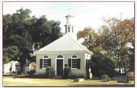
Christ Church, Episcopal, foundation laid in 1707.Photo Nov 1992 by JSD. [Part 1] Two hundred and fifty-three years after Robert Dorrill married Elizabeth Cook in the church of the parish, Christ Church, in 1736, or 276 years after the first mention of Dorrills in the parish, the author, along with his father Doris and brother Robert, made an approximate 150-mile trip to visit the site on Wednesday, 6 September 1989. (Robert and I had made an earlier research trip to Charleston and Georgetown in June 1982, but had not visited the church.) Arising early that morning, then after breakfast in a local restaurant, and in a light rain, we left Augusta, Georgia, around 6:30 a.m., the dawn still a quarter-hour away. Threading our way south-east across town through the going-to-work crowd, we crossed over the Savannah River into South Carolina; the river borders Augusta and divides the two states. Adjacent to the east side of the river, we passed through Beech Island, the first town in South Carolina, then traveling a two-lane rural highway, we skirt the northern boundary of the Savannah River Plant area, a large restricted tract of land encompassing hundreds of square miles, owned by the U.S. Government. The plant is operated by a private contractor (originally Dupont, now recently Westinghouse) for the Department of Energy, producing materials for national defense purposes. (Over the years it has been referred to locally as the "bomb-plant".) Continuing on, we travel through Barnwell, Olar, Ehrhardt, and Lodge. Then, about two-thirds of the way to our destination, and with the intermittent rain continuing since leaving Augusta, we made a coffee-break at Walterboro. Leaving Walterboro, we passed through Jacksonboro, Parker's Ferry, and Osborn before reaching the outskirts of Charleston. Of the nine towns we passed through after leaving Augusta, Barnwell and Walterboro were the largest, either of the two with less than 15,000 population, and any of the others at no more than one-third of that. As we came to the edge of Charleston, the clouds began to clear somewhat, and the rain stopped. It looked as if it might turn out to be a nice day after all. Then crossing the Ashley River, we pass through Charleston, and then across the Cooper River. Within a few miles we reach Mt. Pleasant. Continuing three miles north-east on Highway 17, a heavily traveled 4-lane highway, we abruptly came to Christ Church on the right and quickly turned into the driveway. Directly across the highway from the church is the road (Long Point Road; the "Seawee Broad Path" to "Bermuda Town") that leads to Boone Hall Plantation. The Dorrills, Boones, and Rutledges were neighbors in that area. The Boone Hall Plantation is open to the public as a tourist attraction. On one of the walls in the main house is a framed original plat which indicates that the Dorrills once owned acreage within those plantation boundaries. Also in that area to the north is a Darrell Creek that meanders off the Wando (Cooper) River. As soon as we parked in the church yard, the clouds burst. After waiting awhile and with no indications it would soon let-up, we drove back to Mt. Pleasant to have lunch. This wet weather was caused from Hurricane Hugo which was then far away in the Caribbean, its course to the mainland of the U.S. not yet determined, but in the coming days was to head straight-on to Charleston. The rain did ease off during our lunch break, so while in the Mt. Pleasant area we visited a cemetery on McCants Drive. Although not knowing the exact location of the grave, Angelina (Dorrill) Jervey, daughter of Robert Dorrill, Jr. (b. 1768), is buried there. Her husband Thomas Hall Jervey is buried at Christ Church. With the rain still holding, we returned to Christ Church. After a pleasant conversation with Grace Young, the secretary in the church office, I began to take photographs of the church cemetery and grounds. While there are no Dorrill graves identified by markers in the church-yard cemetery, we know from the Register of Christ Church that there are at least five buried there: (1) Mary Dorrill, died 16 October 1780, daughter of (2) Mary Dorrill, died 13 February 1783, wife of Jonathan. (3) Elizabeth Dorrill, died 13 September 1784, daughter (4) Elizabeth Dorrill, died 29 March 1785, wife of William. (5) Jonathan Dorrill, died 23 May 1788, son of Robert, Sr. After the photo session, we loaded up and headed for home. We arrived back in Augusta around 7:30 p.m., a pleasant one-day excursion, in spite of the rain. A week or so later, the eye of Hurricane Hugo, with 135-mile winds, was to hit the Charleston area. I wonder how well the buildings and stately oak trees survived this onslaught. This I will find out the next time I visit, probably sometime in the Fall of this year (1990). [Part 2] I last reported on a research trip to Charleston/Mt. Pleasant/Christ Church Parish, South Carolina, in Issue No. 6. That trip on 6 September 1989, during intermittent rain and persistent mosquitoes, was a week or so before Hurricane Hugo was to hit the area. I closed the report by saying, "I wonder how well the buildings and stately oak trees [of Christ Church and adjoining cemetery grounds] survived the onslaught. This I will find out the next time I visit, probably sometime in the Fall of this year [1990]." I will report on the aftermath of the storm later in this report; however, I did not return to Christ Church Parish on the mentioned date. I did return to Charleston on 8 January 1992, but I had one specific interest in mind: to visit the library of The South Carolina Historical Society, and that was my only stop. Then, on Tuesday 10 November 1992—the weather cooperating this time, and no mosquitoes as it was later in the season—I returned to Christ Church, the home parish of the first Dorrills in Carolina. The first item on my agenda was to travel out Long Point Road (directly across the highway from the church) and find "Bermuda Town." Adjacent to the north-east side of the Wando (Cooper) River, in sight of Charleston just across the harbor, is a place called "Bermuda Town" which had been laid out before 1699. As early as 1707, there is mention of Long Point Road which ran from the river, passing Boone Hall Plantation on the left, and entering the Old Georgetown Road (which is now Highway 17) at Christ Church. Somewhere on that stretch of Long Point Road between the river and Highway 17, was the Dorrill Plantation and Family Cemetery as noted in the Registers of Christ Church Parish: "On Tuesday Night December ye 30, 1777 Departed this Life Robert Dorrill Senr [b. 1712 or April 1717] and was Enter'd into his Family Burying Ground." It is known that the Dorrills and Boones were neighbors as the original plat of Boone Hall Plantation (framed and displayed on a wall in the main house) indicates that Dorrills once owned acreage within those boundaries. Further, Robert Sr.'s will of 1777 mentions "...one tract of land containing two hundred and fifty acres, more or lefs, which...joins on land of Mr. John Boon and Mrs. Rutledge". I remember the Boone Hall plat from a tour of the home many years earlier during a visit there maybe fifteen or so years ago (thus the middle 70s), and before I was even aware the Dorrills were from that area. This trip, while on the way out Long Point Road, I stopped at the entrance (ticket) booth to inquire if I might proceed on to the main house to take a photograph of the plat, explaining that I did not want to take a tour as I had done this at an earlier time. But, things are never quite that simple. The attendant handed me a business card with a name and telephone number and said I must first obtain permission of the Director, mentioning that she was not, at the present, on the grounds. So, this will be for another time. [But, as of 2003, that time has never come.] Continuing out Long Point Road, as I neared the river end, I was dismayed to find the area developed into a heavy industrial zone, with a shipping/receiving port covering the river frontage. Whatever may have been there 250 years ago is now covered under acres of asphalt paving. Yet, maybe all is not lost. The original Dorrill land and family cemetery, hopefully, is back closer to Boone Hall and before the industrial development begins. I left that area traveling back to Christ Church, with a further search, as before, for another time. [And again, as before, as of 2003, that time has never come. So, I think it can be said that in genealogical and family history research, you do and get all you can the first time as another chance may never come.] Pulling into the grounds of Christ Church, I first noticed that, whatever the aftereffects of Hurricane Hugo may have been two years ago, there was no apparent visible damage, with the large oaks still standing. I stopped in the church office and renewed the acquaintance with secretary Grace Young whom I had met the last visit. The next stop was back at Mt. Pleasant to revisit the cemetery on McCants Drive to find the grave of Angelina (Dorrill) Jervey, wife of Thomas Hall Jervey who is buried at Christ Church. While unsuccessful the first visit in 1989, and still not knowing if there is a marker or monument, I would make another attempt this time. the cemetery is split in half by a low fence that is easily stepped over, with one side identified by a sign: "Saint Paul's Lutheran Cemetery", and the other side not identified. With no previous research indicating that any of the Dorrills were of the Lutheran persuasion (but, of course, Angelina was now a Jervey), I was certain it would be a waste of time to survey that side of the cemetery, so I began to walk the other side. With no success, and not feeling any pressure of time, I said what the heck, I'll look at the other side. After stepping over the low fence, and continuing on a short distance along the fence line, there was indeed the grave of Angelina: the monument had fallen off its base, but was lying face up on the ground. There were other graves of her family on that Lutheran side of the cemetery. [Angelina's family history is included in Book 4: "Robert Dorrill, Jr. (b. 1768) of Christ Church Parish and his Descendants."] Leaving St. Paul's Lutheran Cemetery, I stopped to eat lunch while still in Mt. Pleasant. After lunch, I traveled across the Cooper River into the city area of Charleston. On King Street downtown, was the Charleston County Public Library, my next stop. It was by now getting late in the day, so I figured an hour was about all the time I would have here. Located on the first floor of the library was a separate local and state history enclosure called the "South Carolina room." There is enough material here to keep you busy for days, not to speak of an hour. Before leaving Charleston, there was one other stop I wanted to make, visit the St. Lawrence Cemetery to look for the grave of an allied relative: Jacob Kind. After finding the cemetery, with much difficulty, and then not knowing if there was a grave marker, I decided to keep going. Further, there was no office on the premises, therefore the sexton's records were kept at a different location. All in all, that Tuesday was a very productive day. |